Restoration Photos
CRMP Project Slide Show |
|
Restoration Photos |
|
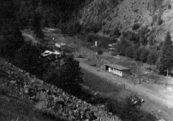
| This photo shows the USGS gauging station on the lower Shasta River in 1953. The small white structure adjacent to the stream houses the gauge. Note the lack of vegetation and then check the next photo to see improvements in stream condition since that time. | |
![]()
[ Home - FAQ - Shasta River Tour - Slide Show ] |
![]()
This site was made possible by grants from the California Dept. of Fish and Game
and the U.S. Fish and Wildlife Service
These pages look best in version 4+ of either Netscape or Internet Explorer
Copyright © 2000 Shasta River CRMP
Site created by SnowCrest Web Design