Restoration Photos
CRMP Project Slide Show |
|
Restoration Photos |
|
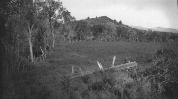
| Improved pasture and riparian zone along the Shasta River just downstream of where the Montague Grenada Road runs today. The photo was probably taken before the 1930's. Note the old fence which protected riparian trees. | |
![]()
[ Home - FAQ - Shasta River Tour - Slide Show ] |
![]()
This site was made possible by grants from the California Dept. of Fish and Game
and the U.S. Fish and Wildlife Service
These pages look best in version 4+ of either Netscape or Internet Explorer
Copyright © 2000 Shasta River CRMP
Site created by SnowCrest Web Design