|
|
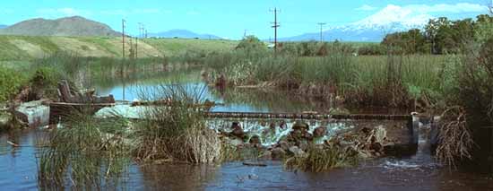
The Shasta River is fed by cold streams that drain rain and snowmelt from the Klamath Mountains, to the west of the valley. The Cascade Range, on the east side of the watershed, also pipes cold water to the river all year via underground channels. Much of the water from upper Shasta River and Parks Creek is now captured behind Dwinell Dam, in Lake Shastina. Flow depletion in the river below the dam compounds water quality problems in the Shasta River. The main water quality problems in the Shasta River are high water temperatures and periodically depressed oxygen levels. Both are affected by flows in the river. The mid-part of the river is low gradient, and it moves slowly across the open, hot valley floor. Unrestricted grazing in riparian zones has led to a decrease in streamside trees and the cool shade they provide. Agricultural water, which is diverted from the river or pumped from the ground, is often very warm when it flows back into the river. Runoff water may be rich in organic matter, which can raise nitrogen and phosphorus levels in parts of the river. Diversion dams slow the river's flow, which allows the water to warm up in the heat of summer. The dams also create a pond-like environment, rich in nutrients, where algae bloom in abundance. In the daytime as the algae release oxygen through photosynthesis the water may become super-saturated with oxygen. At night, photosynthesis stops but respiration continues. The algae now use the oxygen, leaving little for the fish.
From the KRIS bibliographyFor more information about water quality in the Shasta River: Investigation of Water Quality Conditions in the Shasta River, Siskiyou County. California Regional Water Quality Control Board. September 1993. Shasta/Klamath Rivers Water Quality Study. Department of Water Resources, Northwest District. February 1986. |
![]()
| Fisheries | Introduction / Species & Ranges / Life Cycle / Habitats /
Monitoring / Population Trends |
| Water Quality | Introduction / Water Temperature / Dissolved Oxygen |
| Geology | Introduction / The Cascade and Klamath Provinces |
| Hydrology | Introduction |
| Economics | Introduction |
| Restoration | Introduction / Fencing Riparian Areas / Replanting Trees In the Riparian Zone / Water Use |
![]()
| [ Home - FAQ - Shasta River Tour - Slide Show ] [ Bibliography - Links - Contact ] |
This site was made possible by grants from the California Dept. of Fish and Game
and the U.S. Fish and Wildlife Service
These pages look best in version 4+ of either Netscape or Internet Explorer
Copyright © 2000 Shasta River CRMP
Site created by SnowCrest Web Design

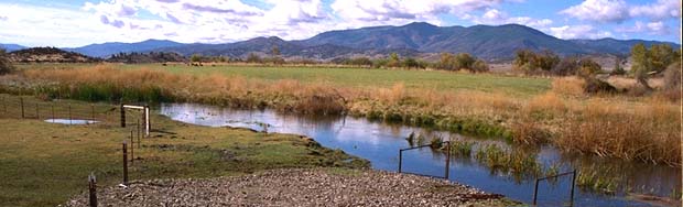 The river moves slowly
over the flat, dry Shasta Valley floor. Ranchers are fencing riparian zones to allow trees to
grow and shade the river. The Klamath Mountains are in the background.
The river moves slowly
over the flat, dry Shasta Valley floor. Ranchers are fencing riparian zones to allow trees to
grow and shade the river. The Klamath Mountains are in the background.