Selected Examples of Mass Wasting
on Mount Shasta
|
A Term Paper
by Bob Musgrove
Geography
581 Geomorphology
Professor: Dr. Mairs
Southern Oregon University |
|
A UNIQUE DEBRIS FLOW
One Friday in August 1999 I was working as caretaker at
Shasta Alpine Lodge, the climber's hut at 8,000 feet in lower
Avalanche Gulch on Mount Shasta. The early evening brought an
intense rain storm which tested the abilities of my tent, and
the following afternoon four climbers reported a mass wasting
event to me. The climbers told me that a slow-moving slide consisting
of small boulders, debris, and water had run past them as they
were descending the mountain. The slide made a loud, rushing
noise which first attracted their attention, and the party actually
had to dash out of the slide's path as it overtook them. Subsequent
interviews of U.S. Forest Service rangers informed me that the
flow continued, off and on, for "a couple of weeks"
and that water had been observed in the slide path (Towner 1999).
My own observations of the mountain yielded two more new slide
scars, both on Shastina, that had originated at similar high
altitudes (above 12,000 feet). I decided to first climb up to
and photograph the Avalanche Gulch slide, and to later interview
Forest Service soil scientist Peter Van Susteren.
|
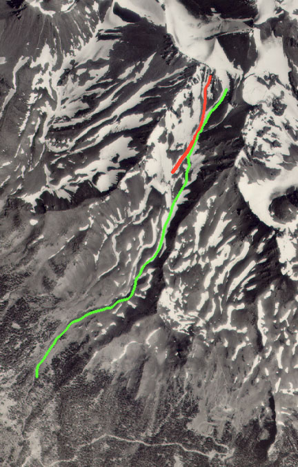
Figure
9. This USFS aerial photograph shows the debris flow in red.
The green line is the path of the January 1997
avalanche. |
| When
I hiked up to the debris flow I found that it originated in the
Trinity Chutes on upper Casaval Ridge, flowed down to an area
below the Heart, and then followed the path of least resistance
to an area just above Lake Helen. Most of the debris flow track
consisted of a trench about 1.5 to 3 meters wide and about 1.5
meters deep with well-defined, miniature levies. Apparently
the debris flow did not have a great deal of momentum because
once the slope angle leveled off above Lake Helen, the track
spread out and deposited material in an a pattern that resembled
several overlapping alluvial fans. The debris flow started at
an altitude of approximately 12,800 feet and slid down to about
10,800 feet over a distance of 1.4 kilometers. |
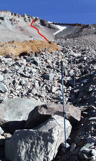
Figure 10.
Photo taken from about 11,000 feet.
The 1.5 meter ski poles are in the trough carved by the debris
flow. The large rocks were left by viscous material dropped the
rocks as it flowed down the trough. |
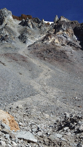
Figure 11.
The point of origin for the debris flow. This part of the flow
is show in red in Figure 10. |
|
Causes of the August 1999 Debris Flow on Mount Shasta
The rainstorm the night before the slide, the properties
of the volcanic materials previously deposited at high altitude,
and the slope angle may have all contributed to the event. As
stated earlier in this paper, shear strength holds material in
place on slopes, and shear failure can occur if the stress is
strong enough to overwhelm the forces of cohesion and resistance
in the layers of material (Easterbrook 1999). In this case,
the addition of rain water to the volcanic debris which was supporting
itself may have contributed to shear failure by lessening the
cohesion of the debris, causing the material to reach its plastic
limit (Van Susteren).
|
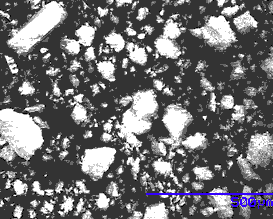
Figure
12. A scanning electron microscope image of the finer material
from the debris flow. The blue line scale in 0.5 mm in length.
Fine particles such as these transported the large rocks in Figure
10.
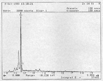
Figure
13. This energy dispersive x-ray analysis for the material
imaged in Figure 12 was produced with the SEM. The spike shows
that silicon is the most common element in the sample.
|
web page authored by Bob
Musgrove
|