October 4, 1998
Links to photo illustrations are at the end of the text.
Gazelle and The Road
A county road meanders west over a saddle between the Scott Mountains and Scarface Ridge from the tiny town of Gazelle to the equally small hamlet of Callahan. We had heard from locals that this was a scenic and safe drive, during non-snow months, and we'd had it on our list of outings for some time. On October 4th the weather and timing was right.
Gazelle is located on a remaining remnant of old U.S. highway 99, about 25 miles north of Mount Shasta. It's nestled at the base of the Scott mountains on a grassy plain sprinkled with grazing cattle. To the southeast rises the cone of Mount Shasta. It's a very pleasant setting that must have looked promising when California's major north-south highway was it's main street. The town then boasted a gas station, and general mercantile store. Both are boarded up now, victims of the Interstate highway system.
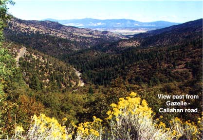
Just before you reach the former gas station a sign's arrow points you west to "Scott Valley Callahan 27 miles." For a mile or so the road takes you through a corner of the flat grazing land and past an oddly out-of-place rock formation that forms the back drop of a ranch house and its out-buildings. The road then begins its climb.
At first the rise is gradual, but after a few miles you reach a section of hairpin turns to accommodate the steep slope of the ridge. At the summit you're rewarded with sweeping views of the Shasta Valley and the twists and turns of the route you've just taken.
The Lake
Soon after reaching the road's high point you begin a gradual descent toward the narrow valley formed by the South Fork of the Scott River. Just before reaching the valley floor we turned south on Rail Creek Road and began another climb in order to reach the intriguingly named Kangaroo Lake. It was a steep ascent of some 8 miles to this beautiful little alpine lake, one of many natural, glacially-formed lakes that dot the complex of mountains stretching west from Mount Shasta to the Pacific. For those of you familiar with Castle Lake, Kangaroo is miniature version about one-fourth the size. Surprisingly, in what we expected to be a semi-wilderness setting, we found a concrete walkway leading from the parking area to a well-designed, native-stone observation deck at the lake shore. This was installed to accommodate people in wheel chairs, but was done so well that it didn't detract from the jewel-like beauty of lake and it's setting. We walked along the shore and watched several anglers trying their luck.
After descending from Kangaroo lake we resumed our drive west toward Callahan. The valley eventually broadened enough to accommodate two or three cattle ranches. The houses and out-buildings, though well-maintained, gave the impression that they had been there for a long time. This was confirmed when a sign over the gateway to one ranch stated that it had been established in 1871. The overall impression was that this little corner of northern California had changed very little in over 100 years. It was somehow reassuring to know there remained such a place.
Callahan and Scott Valley
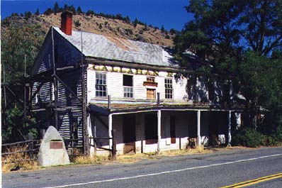
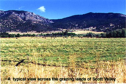
The Gazelle-Callahan road joins California highway 3 about two miles south of Callahan. Highway 3 courses north and south along the west side of Scott Valley -- a broad, level expanse two to five miles wide and 15 miles long surrounded on all sides by mountain ranges. The main Scott River meanders along the eastern side of the valley. Callahan anchors the valley's southern end. At one time Callahan must have been a bustling little community serving the local ranches. It featured the imposing two-story "Calahan Ranch Hotel" and Farrington's General Store, the central establishment of a block of shop spaces along a wooden sidewalk protected by a broad overhang. However, with several modern motels and a WalMart store an easy 30 minute drive north in Yreka, it was inevitable that the services in Callahan would become obsolete. Still it was sad to see the sagging, empty hulk that once was the bustling "Callahan Ranch Hotel" and to read the sun-faded sign in the dusty window proclaiming that this year the Farrington family had regretfully closed their general store "after 130 years of continuous service to their Callahan friends and neighbors."
Etna, Fort Jones, and Yreka
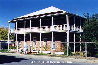
From Callahan we drove north on highway 3 to Etna, the centrally located and most populous town (1500 pop.) in the Scott Valley. Famous for among other things locally brewed Etna beer, it was also the jumping-off place and supply center for the gold miners who prospected in the surrounding mountains from the 1850Ős on. There are a number of lovingly restored Victorian homes in Etna and a few prospering shops including one that sells Apple computers. In front of an interesting two-story brick house, more reminiscent of New Orleans than the far west, a carrot-topped youngster was selling home grown tomatoes. Succumbing to his Sawyeresque charm we purchase two boxes.
Leaving Etna we continued north toward Yreka and the WalMart Store. On the way we passed through the northernmost town in the Scott Valley, Fort Jones -- another base for the early day gold miners. There seemed to be evidence of a bit more energy and civic pride in Fort Jones than in Calahan -- but then it may consider itself a suburb of Yreka with its modern motels and Walmart Store.
The drive over the mountains from Scott Valley to Yreka is scenic but much shorter than the Gazelle-Callahan route. Following our shopping at WalMart we ramped onto I-5 heading south for home. As we cruised down the interstate in the late afternoon sunlight, it felt as if we had been through a time machine and experienced a little corner of California that remains in the 1870Ős.
Illustrations